Hurricane Florence may only be the start
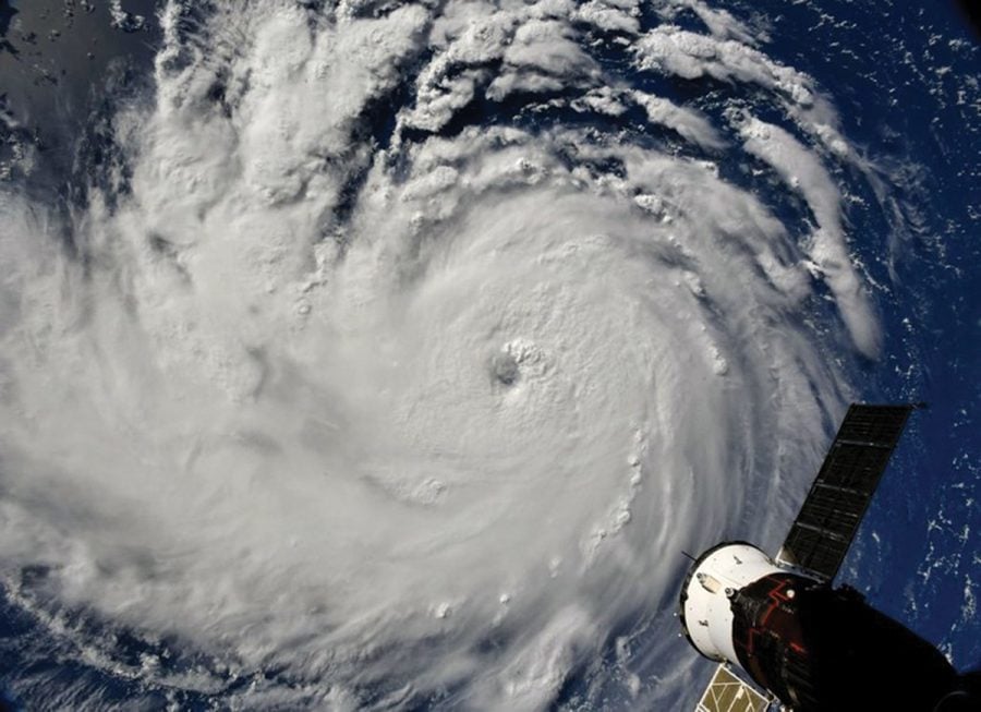
Hurricane Florence photographed from the International Space Station on Sept. 10, 2018. // Photo courtesy of NASA
Hurricane Florence made landfall early Sept. 14. on the coast of the Carolinas, bringing strong winds, high storm surges and torrential rainfall. Florence developed off the west side of Africa and had a rocky track up to the United States coast. Florence gathered immense power and became a Category 4 hurricane twice, but other weather factors like wind shear and colder waters helped the storm weaken before hitting the United States.
“The wind shear is what cuts off the tops of the hurricanes and keeps them from building up,” said Katheryn Cooper, environmental science teacher at the Early College at Guilford.
For this year and the past year, however, the wind shear has died down due to a possible El Niña effect taking over, increasing the threat of powerful storms that are likely to hit the United States. Even then, Florence could be historic for North Carolina because the sheer amount of rainfall and flooding.
Florence’s odd course began with its wobbly path coming up north in the Atlantic Ocean. It started out far in the middle of the Atlantic Ocean and normally hurricanes in that path tend to veer toward the European continent, but Florence did not. Most hurricanes of a Category 4 intensity do not make it up this far north where there is cold water, but Florence did. This would make it one of the few hurricanes to strike this far north with such high potential for destruction. Meteorologists originally predicted that Florence would hit the North Carolina coast, but as the storm drew closer the path pivoted toward South Carolina, adding to the strangeness of this hurricane.
Florence struck the coast as a Category 1 hurricane with wind gusts up to 90 mph and heavy rainfall, quickly proving that weaker does not mean harmless. Another factor making Florence a dangerous storm was that it would linger over the Carolinas because of a high-pressure system preventing the hurricane from moving up and away. The biggest threat concerning Florence was the flooding of many low-lying areas and of already full waterways. More than 15 inches of rain was expected in some parts of North Carolina, according to weathermodels.com. The storm discharged a grand total of 18 trillion gallons of rain onto the Carolinas. Schools and businesses all over the state shut down as people buckled down for the long rainstorm.
In the wake of Hurricane Florence, several other hurricanes and typhoons are posed to strike various places all across the globe. Super typhoon Mangkhut struck the Philippines on Saturday, Sept. 15, and Hurricane Olivia is ready to fall upon the Hawaiian Islands. The Earth Observatory website points out that this pattern of incredibly powerful storms appearing with high frequencies has become more apparent in the last couple years. Less than a year ago, the U.S. took direct hits from three Category 5 hurricanes, Harvey, Irma and Marie which caused devastating damage and a multitude of fatalities.
“Stronger hurricanes are coming up,” Cooper said. “Why do they wait till September? Because water takes longer to heat up, so it took all summer for the energy to build up in the water itself to build these hurricanes.”
With global temperatures on the rise and humans feeding back into the changing climate patterns, this possibility of constant destructive forces of nature battering down on humans could become a reality for the world’s population in the near future, says the Union of Concerned Scientists.
Fastweather.com measures that in Greensboro, Hurricane Florence brought down 5 inches of rain and caused some flooding and power outages. The wind is stronger and flash flood chances are high. But with people taking proper precautions and staying careful, the worst can be avoided.
Guilford classes were cancelled on Sept. 13, 14 and 17. Heavy rains kept many students off the road.
“My weekend plans are cancelled,” said junior Beka Bililgn.
Guilford students, including junior Te’Lisha Graves, took precautions over the weekend.
“It pretty much made me very paranoid after watching the news,” Graves said. “I was expecting the worst. I communicated with my family to prepare for the hurricane. I thought it was better to be overly prepared than not prepared at all.”
Within the following weeks, lots of communities in harder hit areas will be recovering from the flood and wind damage. According to CNN, as of Wednesday, Sept. 19, this tropical storm has claimed at least 36 lives and will cost a great deal to replace the infrastructure.


